| Home | Newsletter | Locations | Diary |
|
Indexes |
|
|
|
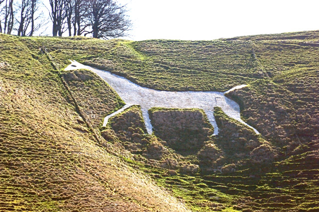
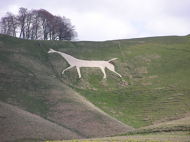
Visible from the A4 coming from the Calne or Chippenham direction going east towards Marlborough. This horse is on a steep NW facing slope, has been a prominent and well maintained landmark for many years. Before mass tourism, climbing the hill to this horse and the other items on the top, ranked with Stonehenge, Avebury and a few others, and was by most people, the best known of the Wiltshire white horses, although not the oldest. The Cherhill White Horse is said to be the second oldest of the Wiltshire horses. Created by a close friend of George Stubbs, famous for his paintings of horses and other animals, some say the artists influence can be seen, and that this is the most realistic portrait of a horse. Westbury is older, and was recut to a new design two years before the Cherhill horse was created, and perhaps the interest this created was the inspiration that led to this horse. It was cut in 1780 by Dr Christopher Alsop of Calne, known by some as "the mad doctor". It is reported that he directed the marking out of the horse from a distance, calling instructions through a megaphone. The location chosen is just below Oldbury Castle an earthworks fort. Placed high on a steep slope, the horse is easily visible from below and from a distance.
This white horse at one point had a glass eye. The centre of the eye was formed from upturned bottles pressed into the ground to reflect the sunlight. These became souvenirs as did a later set replacing them, today the eye is made of concrete. I have read that in the 1950's some children would slide down the horse features on trays or in sacks. I think this must have been an occasional practice by a small number of local children, as I visited a number of times in the late 50s and through the 60's and later and did not see this. In the 1950's few families had cars, and there is no sizable population anywhere near the white horse. It has over the years generally been well vested and looked after, but with increased tourism is showing the effects of time. A major restoration was carried out during August 2002, involving re-cutting the outline of the horse, fixing shuttering to hold the chalk in place, and resurfacing the horse with 160 tonnes of fresh chalk. Nearby is the obelisk known as the Lansdowne Monument. At one time the monument was open, and could be climbed, but not for many years now. In the centre of Devizes is an ancient stone bearing an inscription in very old English, telling how a lady swore an oath, I can't remember the exact details but in effect she said that god should turn her to stone or salt or something if it was not true, and on her way home across this ridge she was turned to stone. People point the monument out as this individual but the monument is later and has another dedication, up close its also huge, so there must be another stone along the ridge at some point, to go with the Devizes stone.
Oldbury Castle is often overlooked, triangular in design, with
double banks and ditches, it is the highest point giving all round views,
over a very large distance A magnetometer survey, has shown an even older
settlement on the same site. Located at SU049693, it is sometimes said to
be the highest of the Ridgeway forts, but is in fact some miles from
The
Ridgeway
The stage coach root was along the current path of the A4 although narrower. Stage coach horses were changed at Calne not far away, and there is a detailed report on the wall of a local pub on the side of the hill, of how highwaymen would hold up coaches as they slowed down climbing the hill at Cherhill going east, but no one could remember what their faces looked like. Their unusual feature was that these were always several nude highwaymen.
.
Please let us know any other information that we can add to the Further information and Planning Grids or page and any errors that you discover. Before making a long trip to any location it is always wise to double check the current information, websites like magazines may be correct at the time the information is written, but things change and it is of course impossible to double check all entries on a regular basis. If you have any good photographs that you feel would improve the illustration of this page then please let us have copies. In referring to this page it is helpful if you quote both the Page Ref and Topic or Section references from the Grid below. To print the planning grid select it then right click and print the selected area. Please submit information on locations you discover so that this system continues to grow.
|
||||||||||||||||||||||||||||||||||||||||||||||||||||||||||||||||||||||
. |
||||||||||||||||||||||||||||||||||||||||||||||||||||||||||||||||||||||
|
||||||||||||||||||||||||||||||||||||||||||||||||||||||||||||||||||||||
|
|