| Home | Newsletter | Locations | Diary |
|
Indexes |
|
|
|
|
Maps |
|
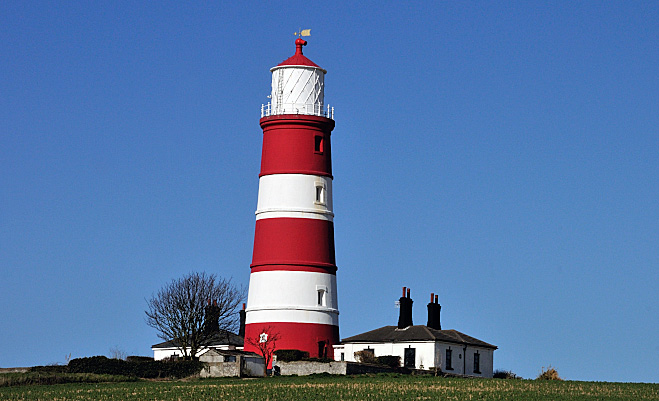
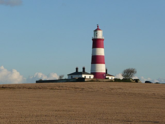
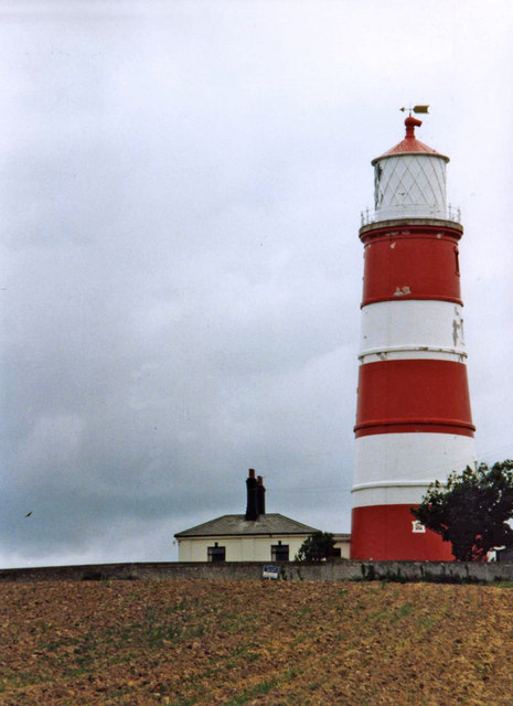
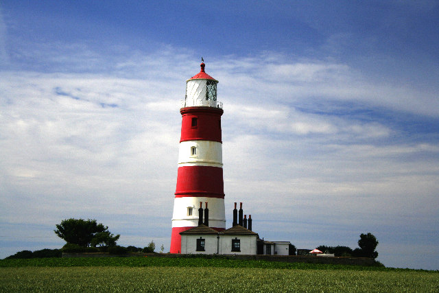
Happisburgh Lighthouse is the oldest working light in East Anglia, and the only independently run lighthouse in Great Britain. It is run by a local trust and open to the public many Sundays and some Mondays. See grid below.
Built in 1790, it was originally
one of a pair, this higher back one and a shorter one near the cliff top. The pair
formed leading lights marking safe passage around the southern end of the
treacherous Happisburgh Sands. The 20ft lower 'low light' was discontinued in
1883, when cliff erosion meant it was going to fall into the sea, it was then
demolished to ground level in 1883 or shortly after. The lantern and optic
removed from the low light and installed at
Southwold
Lighthouse
The remaining tower is 85ft tall and the lantern is 134ft above sea level, and continues in operation. The lighthouse is painted white with three red bands, so it's not confused with another one, and has a light characteristic of 3 white flashes, repeated every 30 secs and has a range of 18 miles. In some of the images we have on this page paint can be seen to be peeling, this occurred following a repaint in 1994 when the wrong sort of paint was used. This was not the repainting of the lighthouse in the "Challenge Anneka" television programme in 1990, as I have seen reported. The lighthouse has, like many, two keepers cottages next to it. Inside the tower, 96 stone steps wind up the inside of the perimeter wall to the service room directly below the light. In olden days this room was used to store oil and other equipment which was winched up from the bottom of the Lighthouse. Today it houses a light sensitive cell, a type of 'trip switch' which activates the lamp as conditions darken outside, both at night or during stormy and foggy weather. From the service room, up a few stairs leads to the lamp room, where the main 500 watt sits within a large 'optic' of prisms for refraction and magnification of the light. The light flashes three times every thirty seconds with a 1.5 second gap between flashes and it is this unique pattern which gives the identity of the lighthouse to the shipping offshore. The reserve bulb, will move across to replace the main bulb if the main bulb fails for any reason and, in case of a power cut, a battery powered back up system is in place to take over the operating of the light, which can last for up to eleven days if necessary. The prisms are the original glass prisms dating from the 1860's. The back of the lamp room is painted black to enhance the clarity and visibility of the light offshore.
The History This lighthouse has two histories, firstly its original creation and its operation through to modern times by Trinity House, and the later story of how it come to be run now by a local trust, the only independently run lighthouse in Britain. As this is so unusual lets start by looking at this later part of the story. Today, as you might expect there are many later navigational aids taking over from the older ones, from radio and radar beacons to satellite navigation systems. As this is happening Trinity House and others are reducing the number of traditional lights and lighthouses. In 1987 Happisburgh Lighthouse was one of five lighthouses declared redundant. Decommissioning was scheduled for 13 June 1988. In addition to the 5 lighthouses scheduled to close in 1988, there were four light vessels, several fog signals and numerous buoys and minor lights. A local campaign was put together to save it, because they felt there was a real need, as a back up when other systems failed and perhaps for those who didn't have all the latest toys. Under the Merchant Shipping Act of 1894, Trinity House can only dispose of a working lighthouse to an established Lighthouse Authority. So in addition to covering the cost of running and maintaining the light they also had to raise funds to promote a Private Bill through Parliament. This they were successful in doing and on 25th April 1990 the Bill received the Royal Assent. The passing of the Bill made Happisburgh the only independently run lighthouse in Great Britain. The HAPPISBURGH LIGHTHOUSE TRUST was established as a 'LOCAL LIGHT AUTHORITY'. The Trust is a registered Charity governed by six appointed Trustees who are responsible under the Act of Parliament for operating and maintaining the Light. In 1991 Happisburgh Lighthouse celebrated its bi-centennial anniversary on New Year's Day. It is the oldest working light in East Anglia and the only independently operated Lighthouse in the UK. Its still run by the Trust with funds they generate.
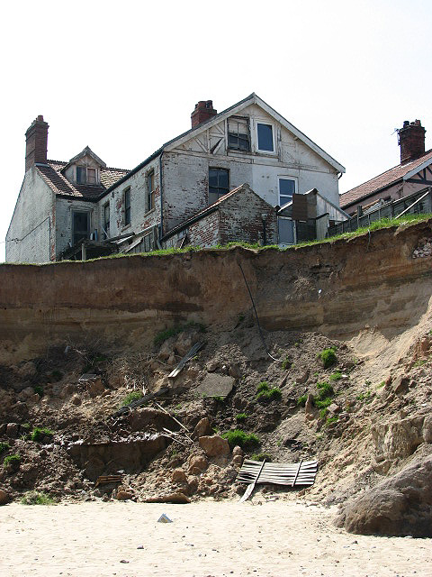
In 1863, prior to the gas conversion, a new lantern was installed and it's the one in use now. This improved visibility of the light from sea. In 1868 new optics were added. At that time the light was constant rather than flashing and the range was 17 miles for the tall and 15 miles for the low light. Twenty years later in 1883, the low light was going to fall into the sea due to erosion, so the low light was demolished down to foundation level, and later in the 1940s and 50s the foundations were to fall into the sea. Often now, as sands shift about, chunks of masonry foundations of the low lighthouse become, for periods, visible on the beach below the cliff. So as to make it clear which light was now showing they switched from a constant light to an occulting light shining for 25 seconds followed by a 5 second eclipse. To overcome the risk of misidentification in the day time, they added the three broad red bands that we have now. Lights changed, 1910 to paraffin, 1929 to acetylene, and electricity in 1947. Keepers were present up to the Acetylene light source being used, then keepers were not required all the time, and occasional maintenance became the new method. The two keepers cottages were sold a bit after this and are still private houses. In 1947 when they switched to electricity, using a 500 watt lamp, they gained an increased range by a mile to 18 miles. The stand by light continued to be powered by acetylene. The character of the light was now altered to a flashing sequence - 3 white flashes every 30 seconds.
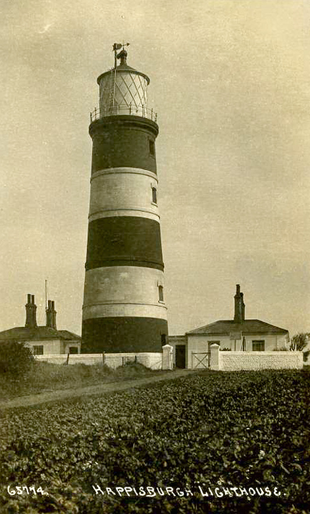
Postcard view from around 1920 You can visit the lighthouse, see details in the 2 grids below. Some remains can at times be seen
of the Low lighthouse that fell over the cliff, this is in the form of chunks of
masonry on the beach, as seen in
photo
The North Norfolk District Council has been given £3 million, to trial new ways to address the consequences of changes to the coast and the impact this may have on coastal communities. This includes clearing cliff top areas that will fall into the sea, the council acquiring properties that will fall, and leasing them short term until they are no longer safe, relocating a caravan business, removing beach debris, and a heritage project to record the history of the village for future generations. The project will conclude with a party in about April 2011 to celebrate the villages future.
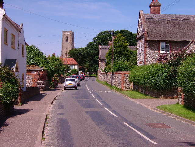
There is more to see at Happisburgh This is a picturesque small village with loads of character waiting to be explored, but don't leave it too long, as some of it at least is being eaten up, or rather surrendered to the sea, although the local council are keen to stress that a lot of it is not immediately threatened. From many years back cliff erosion has been an ongoing problem for the people of this area, as we saw above, the low lighthouse was lost when it was going to fall into the sea. Today its the place in the UK with the fastest coastal erosion and houses are being lost. I am told that it may however take up to 100 years or more before the centre of the village is threatened. Some see this as the village having a secure future, while others do not. Of course this could be stopped if the powers that be chose to, but like a lot of the coastal defences of the UK, its considered low priority, simpler to just give up, unless its threatening a major city or town of course. Perhaps its a good job I am not a politician I would get all the priorities wrong, I would stop this erosion and make this area safe, as well as other areas like it, no money they may say, but you could do this on so little that it need not effect anything of value. Forget funding sports events, twinning towns, embassy parties, arts fund grants for crazy items.......
There are two organisation for those
affected, the local Coastal Concern Action Group,
The Village They also have a
coastguard
rescue station,
The 110ft church tower is also open on some
dates and from the top of the 133 steps, you can see 30 churches, 2
lighthouses, 7 water towers, 5 corn mills, 5 drainage mills, 2 wind farms, Trimingham
Golf Ball (RAF Radar installation), Bacton Gas terminal, reefs at Sea
Palling and the Cathedral spire in Norwich (approx. 16.5 miles away). Entry cost
is £2 adults, £1 children,
minimum height 4' 7".
For more details
click here.
When the tower does open again - please note the minimum height limits for the church tower, this is extremely unusual, you might think peculiar, except with a fair ground ride. The 4ft 7inch limit will eliminate quite a lot of children especially younger teenagers from families that are generally not very tall, and will eliminate some adults as well. The lighthouse also has a 1m height restriction, I understand their height restriction is so that people can definitely reach the handrails and is stipulated by their insurance company. Its not a restriction I have come across in any other lighthouse that is open. Trinity House guidelines do place some restrictions but a 1m height restriction is not part of them.
.
Please let us know any other information that we can add to the Further information and Planning Grids or page and any errors that you discover. Before making a long trip to any location it is always wise to double check the current information, websites like magazines may be correct at the time the information is written, but things change and it is of course impossible to double check all entries on a regular basis. If you have any good photographs that you feel would improve the illustration of this page then please let us have copies. In referring to this page it is helpful if you quote both the Page Ref and Topic or Section references from the Grid below. To print the planning grid select it then right click and print the selected area. Please submit information on locations you discover so that this system continues to grow.
|
||||||||||||||||||||||||||||||||||||||||||||||||||||||||||||||||||||||||||||||||||||||||||||||
. |
||||||||||||||||||||||||||||||||||||||||||||||||||||||||||||||||||||||||||||||||||||||||||||||
|
||||||||||||||||||||||||||||||||||||||||||||||||||||||||||||||||||||||||||||||||||||||||||||||
|
|