Article
Antonine Wall
|
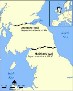
The 37 mile Antonine Wall in Scotland was constructed
by the Romans, construction started in 142AD at the order of
Roman Emperor
Antoninus Pius
 and took
around 12 years to build. It became then, for period, the revised northern
frontier of the Roman Empire. After 20 years the wall was abandoned and
the northern frontier reverted to
Hadrian's Wall. and took
around 12 years to build. It became then, for period, the revised northern
frontier of the Roman Empire. After 20 years the wall was abandoned and
the northern frontier reverted to
Hadrian's Wall. 
In 208AD
Emperor
Septimius Severus
re-established legions at the wall and ordered repairs; this has led to
the wall being referred to as the Severan Wall. This use ended
only a few years later, and the wall was never fortified again.
The location chosen was for
much of its length utilising the high ground along the southern edge of a
valley. This valley is formed by the River Carron, flowing eastward into
the Forth, and the River Kelvin, a tributary of the Clyde in the west.
Together, these rivers helped to create a boggy foreground to the Wall
before the land rose up to the Campsie Fells to the north.
The
design, as often happened with Roman constriction changed several times,
with the original design being a stone wall with few forts to a turf
wall on stone foundations with a far larger number of forts.
|
 Click on map to see
a Click on map to see
a
larger version |
This was not a peaceful area, then after their struggles with the
barbarians, they would create decorative slabs, and 20 of these still
survive.
Unlike
Hadrian's Wall
where large sections survive, little of the Antonine wall
survives today. Most of these remains are now under the care of
Historic Scotland,
and is a part of the UNESCO World Heritage listings as a part of the Roman Frontiers. See
World
Heritage Sites
and
World Heritage Sites in the UK.

You can get an idea of what can be
seen by looking at the photos below and following up the other links to
photographs at the bottom of the page.
The wall was about 13ft (4m), made of layers of turf, with some earth in
places. On the north side there was a large ditch and to the south a Roman road
known as the Military Way. The spoil from the ditch was used to form a wide low
mound to the north. It was built and maintained by soldiers of the three legions
of Britain – the II Augusta (from
Caerleon
 in
South Wales), the VI Victrix (from
York), and XX Valeria Victrix (from Chester). Other inscriptions show that some
Forts and repairs were done by both legionaries and auxiliary units. in
South Wales), the VI Victrix (from
York), and XX Valeria Victrix (from Chester). Other inscriptions show that some
Forts and repairs were done by both legionaries and auxiliary units.
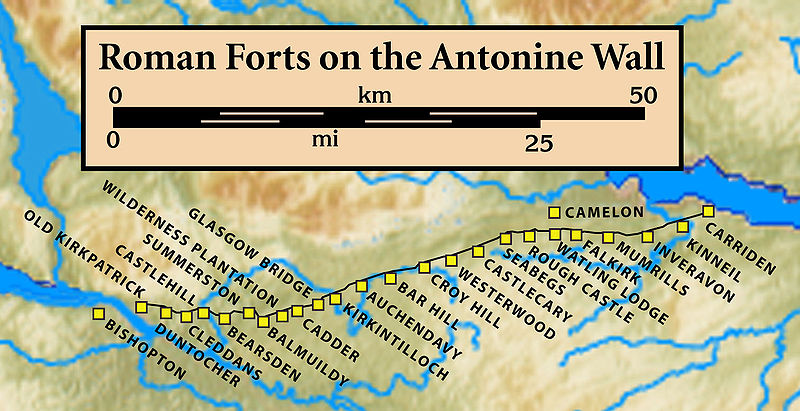
The original plan was to have forts every 6 miles but
this was changed to be every 2 miles. There was a total of 19 forts along the
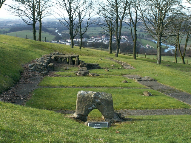
wall. One of the best preserved and also one of the smallest is Rough Castle Fort. As well as
the original forts there were 9 smaller fortlets, which was probably part of the
original plan, but most of these later were changed into forts. The best example
you can see today of a fortlet is at Kinneil. The position of the known forts is shown in the map below.
Supporting the wall there were a number of coastal forts including in
the east
Inveresk
and to the West Outerwards and Lurg Moor). A number of other forts
further north were brought back into service in the
Gask Ridge
area, including
Ardoch,
Strageath,
Bertha
and probably Dalginross and
Cargill.
Throughout history it has been seen and written about,
often by other names, these include the Wall of Pious, Antonoine vallium, and
Grims Dyke. Grims means devil and there are a lot of grim or devils ditches both
in Britain and other countries.
It was not until 1764 that the wall was mapped and this
was undertaken by William Roy of Ordnance Survey, some of what he mapped
has since been destroyed by later developments.
Today you can visit some parts of the wall including some
sites that are in the care of Historic Scotland (HS), open to the pubic and Free to
visit. These include:-
The best points to see today are said to
include:-
-
The location – especially
the central sector, running over Croy Hill and Bar Hill near Kilsyth. The
ditch here is well preserved, as are the beacon platforms on Croy Hill and
the fort on Bar Hill.
-
The fort at Rough Castle –
where the earthworks of the fort and annexe are visible, together with a
stretch of the rampart and ditch, and the Military Way with some quarry
pits.
-
The bathhouse and latrine at
Bearsden – where the Roman authorities provided two forms of bathing as
well as central heating for their soldiers.
-
The Iron Age Fort on Castle
Hill next to Bar Hill – where there are good views towards both Forth and
Clyde.
However I would suggest you look at
the links to the Historic Scotland pages on each of these sites and explore the
photographs below and links from our other photo links below, before planning a
journey, as the amount to see in any of these locations is very limited compared
to
Hadrian's Wall
and other
Roman and historic remains.
The article on
Hadrian's Wall
contains both information and a chart showing the history of both
walls. Also the article
Roman
Frontiers
may give a wider view.
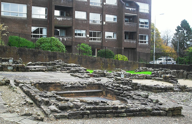
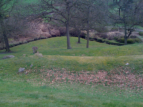
Remains of a roman
bathhouse at Bearsden,
by the wall at NS546721
 Photo by
Lindsay
Robertson
Photo by
Lindsay
Robertson
Barr Hill Roman baths
NS707759
Photo by
Jim Bain.
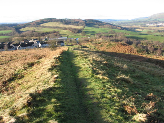
Course of the Antonine
Wall at Croy Hill Photo by
Chris Wimbush
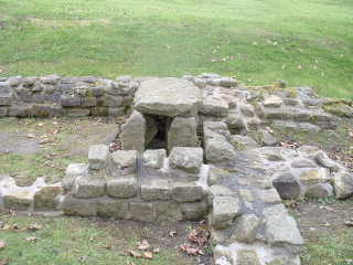
Rough Castle on Antonine
Wall
 Photo by
Dan Smith Photo by
Dan Smith
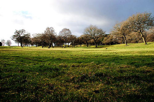
Photo from
Flicker
|
 |
Left - Remains of a Fort
on the Antonine Wall at Barr Hill near Twechar
Photo from
Wikipedia
Commons
|
|
