| Home | Newsletter | Locations | Diary |
|
Indexes |
|
|
|
|
|
||||||||||||||
|
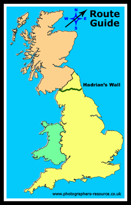
The Hadrian's Wall Path is one of the 15
National Trails
Hadrian's Wall itself is a World Heritage site and the very ground that the walk travels and therefore under your feet is a Scheduled Ancient Monument. Along the path there are sites of Scientific Interest and Areas of Outstanding Natural Beauty and Northumberland National Park. You can walk the path in either direction or in many sections and taking a look at the Preparing for Your Journey section below will point out some of the ways and tools available for you to plan, organise and determine the best way to tackle it. We have decided in this guide to travel from the East Coast to the West Coast, and have split this guide into 3 parts so that we can do justice to the many attractions on route.
Preparing for your journey Although as a National Trail Hadrian's Wall Path is fully signposted, and is in most places obvious, it is always a good idea to both look at maps of the route ahead of your journey and take a map with you. Our information gives grid references throughout, and in most places also links to online mapping services, that should pop up in a new window, with the point being looked at marked. Ordnance Survey maps ??? and ??? cover the route at a scale of just over an inch to the mile. If you are not going to purchase a map then I suggest you zoom back, and print out sections of the OS maps from Multimap that cover the areas that you are going to walk. Look particularly for any place where confusion may occur, such as where there are several trackways, the trackway changes direction and another trackway goes on and places where you leave a road onto a path or trackway. I always work on the theory that signposts could have gone missing or may not be obvious. Walking is also more enjoyable when you can identify what you can see and know where you are at all times. Within this page and on linked location guides you have far more information on the highlights along the path, and there are probably more on this route than any other. There are links to aerial photos in many places, which may give you a better idea of what is there. Google aerial photos are clearer and flow more smoothly and with far less delays than the Multimap versions, but Google mapping currently does not go down to the walking detail, so I would suggest you use Multimap for looking at the route mapping wise and if you want to follow it from an Aerial photo then use the Google aerial photos. The tourist area which deals with Hadrian's Wall Country produce a guide 'Walking in Hadrian's Wall Country' which details 15 different walks including 2 walking itineraries, that incorporates using the special bus service AD122, the Hadrian's Wall Country bus service, which travels the full length of the Wall from Newcastle to Carlisle. It only runs from April until October but there are other local and regional bus services running all year, but these won't stop or cover as many of the wall attractions. The two itineraries both end at Gilsland, but you start from opposite ends of the Wall, the 5 day (3 walking days) Cumbrian walk starts at Carlisle and the 6 day (4 walking days) Northumberland walk starts at Newcastle Upon Tyne. Using this guide you can put together your own itinerary that take in parts of the wall within your own abilities. In total the wall is linked to over 80 shorter walks and many shorter circular walks, allowing you to see as much or as little as you want in any visit. The book National Trail Guide on 'Hadrian's Wall Path' is a more detailed guide to the path and has split the route into 6 convenient sections. It gives more background information, with photographs, on archaeology, local history, wildlife, geology, industry, villages on route with facilities for walkers, and so on.
Continue to part 2
|
||||||||||||||
| Further Information National Trails
http://www.nationaltrail.co.uk
Wikipedia
Book Rotator
Please let us know any other information that we can add to the Grid(s) or page and any errors that you discover. Before making a long trip to any location it is always wise to double check the current information, websites like magazines may be correct at the time the information is written, but things change and it is of course impossible to double check all entries on a regular basis. If you have any good photographs that you feel would improve the illustration of this page then please let us have copies. In referring to this page it is helpful if you quote both the Page Ref and Topic or Section references from the Grid below. To print the planning grid select it then right click and print the selected area. Please submit information on locations you discover so that this system continues to grow. |
|
|||||||||||||
. |
||||||||||||||
|
||||||||||||||
|
|
||||||||||||||
|
Location: |
|
| Grid Reference: | Ceremonial County: |
| Map Link: | Aerial photo: |
|
Getting there: |
|
| Website: | |
|
Other useful websites: |
|
| Other Relevant Pages: | |
|
Notes: |
|
|
Location: |
|
| Grid Reference: | Ceremonial County: |
| Map Link: | Aerial photo: |
|
Location Guide: |
Gallery: |